Day 15: Moab to Green River
If you are acrophobic, do not try to hike Fisher Towers on a cold, fiercely windy day. We made it almost all the way to the end of the trail, but some tears may have been shed coming back down.
 |
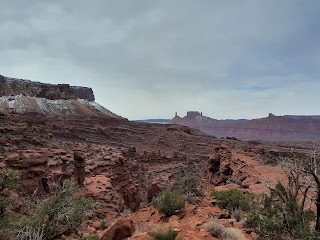
| View across the valley from the trailhead. Lovely day. |
 |
| Another view across the valley. |
 |
| Hiking up... |
 |
| ...and up |
 |
| ...and down this 8-foot ladder... |
 |
| There's a section on ladders in the Rules of Acrophobia. |
 |
| Sigh. |
 |
| ...and up... |
 |
| ...and back down... |
 |
| Sunlight! |
 |
Driving out of the valley. The reef straight ahead
is the edge of Arches National Park. |
Next hike:
Corona and Bowtie Arch Trail. Although it involves arches, this trail is west of Moab, outside of Arches National Park. Corona Arch is spectacular: 105 feet high, 140 feet wide. There were some challenges for the acrophobe, but slickrock is much grippier than the crumbly Moenkopi sandstone of Fisher Towers, the ledges were much wider, and the sun was out. Plus there was a cheerful fairy godmother offering how-to-get-down advice at the trickiest spots to get down, which helped too.
 |
| Petroglyphs on the road to the trailhead |
 |
Some of the slickrock was steep. Climbing up here was pretty easy.
I slid on my butt coming down, which was also pretty easy. |
 |
| This 8-foot ladder is acrophobe approved. |
 |
| First view of Corona Arch |
 |
| We've only seen two blooming plants on this entire trip. |
 |
| Bowtie Arch |
 |
| View back down into the valley |
 |
| Can you spot S under the arch? |
We stopped back in Moab to tank up.
Last hike of the day:
Dead Horse Rim Trail Loop in Dead Horse State Park, which offered great views of the surrounding land and made everything look much less high, since it was all far below us.
 |
| Der Wanderer über dem Nebelmeer collection continues. |
Day 16: Little Wild Horse and Bell Canyons, plus a valley of Goblins
We made Green River our last stop so that we could hike one last slot canyon loop trail: Little Wild Horse and Bell Canyons. The signage says this is the most popular hike on the San Rafael Swell. It's an hour's drive from Green River, into the a very remote area--yet all of the roads are paved, which makes it easily accessible. There were five or six cars in the parking area, which made it two to six times busier than any of our slot canyon hikes in Grand Staircase - Escalante. The canyons include all sorts of boulders and ledges and puddles to climb over, and Little Wild Horse canyon is impressively long, but the slots were never as narrow as the other slot canyons we had walked through.
 |
| Check out the thickness of this bark! |
 |
| My favorite photo of Carly on this entire trip. |
 |
The striations looked like a topo-map. It felt
like we were walking through a fractal. |
 |
| Big rock--enough room to duck under. |
 |
Judging by the colors, a relatively recent rock fall in Bell Canyon:
red iron oxide on the outside, unoxidized sandstone on the inside. |
Little Wild Horse and Bell Canyons are just a few miles away from the equally remote Goblin Valley State Park. This former tidal pool must be a giant mud/clay-slip field when it rains, but when it's dry, you can tromp around the hoodoos.
The photo below was taken in Goblin Valley State Park, where of course one should only drive 10mph--but the thought of driving across the topology of Utah at 10mph made me laugh.
After hiking, we returned to small-town Green River, which is a tad empty in mid-March. I figured it would be pretty easy to nab a Strava Local Legend title there, and hold onto it for a few months (vs. the mere
24-hour taste of legendry I experienced at Horseshoe Bend), so I convinced S to walk the 0.3-mile
Riverwalk near the John Wesley Powell River History Museum with me a whopping four times. Only problem was that the Riverwalk wasn't yet a Strava-recognized "segment," so S attempted to turn it into one on our fourth time walking the trail, without success. So much for that.
Green River claims to have the World's Largest Watermelon slice. It's parked in the lot behind the John Wesley Powell River History Museum, on a trailer with a few flat tires--so if we hadn't aimed for that Strava Local Legend title, we never would have seen it.
 |
| Schmusi schmusi mit dem G'spusi |
 |
| The Green River runs through Green River, UT. |
The next day we drove back to Salt Lake City, went for a walk in Liberty Park, ate lunch at a vegan dive where Utahans actually insisted on wearing masks, killed an hour at the Museum of Contemporary Art, hopped on the TRAX to the airport, and flew away. The End.
 |
At the Utah Museum of Contemporary Art: "Vote for War" postcards
paperclipped to voter registration forms, by Trevor Paglen (2016) |
Our top three places to explore if we come back (unordered):
Capitol Reef National Park; Grand Staircase - Escalante National Monument; and Natural Bridges National Monument. And as long as we're in the area (ha! this is how you get five places on a list of three), the ruins and canyons around Bluff and Blanding, and Canyonlands National Park.