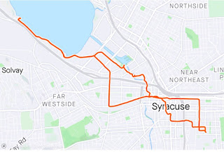
On the Friday of the National Week Without Driving challenge, I flew to Syracuse, NY, because I was presenting a writing workshop on Saturday.
How does one get from my home to the airport at 5am on a Friday?
Mass transit is not an option. We have no light rail to the airport. We have bus service, but the earliest weekday bus leaves the downtown Durham station at 5:42am, and takes a little over an hour to get to Terminal 2. My flight left at 6:45.
My choices: 1) take an Uber, $40+ one way excluding tip; 2) ask a friend to get up at 4:something a.m. to give me a ride; or 3) drive myself there in 20 minutes, park in the convenient garage right across from the terminal, and have my car waiting for me when I landed back at RDU at 11:30pm Saturday night so I could drive myself home.
I drove.
Once I landed in Syracuse, I had almost 6 hours before I needed to meet up with my workshop hosts. Since I was significantly behind on walking miles for the week, I plugged my cellphone charger into an outlet at the airport and looked up potential walking routes from the airport to my hotel near the university.
The two options I found were 9 and 11 miles.
Since I was traveling with only a light backpack, walking was a real option--except that I didn't know the area. I googled crime statistics, and the areas I would need to walk through had lower reported crime rates than the neighborhoods around the university.
The 9-mile option offered a designated bike trail--the Bear Trap Creek Trail--that offered a safe route for 3.8 miles paralleling the freeway, and would end near neighborhood roads that looked easily walkable on the map--except that getting from the airport to the start of the trail involved a big freeway interchange that looked potentially challenging. The 11-mile route required cutting around the back of the airport on a cargo road through an industrial area that looked like it would probably be an ugly slog.
I took an Uber (~$30 including tip, expense covered by workshop hosts).
I asked the driver his opinion about whether walking the whole way was actually feasible. He was confident it was, and changed his route to the hotel so that he could point out a potential road to walk on. "Look at how wide the shoulder is," he said; "it's like that the whole way!" Having walked on a lot of shoulders in Durham, it looked doable, if largely commercial. Maybe next time.
When I checked in at my hotel, I asked whether there was a safe walking route to Lake Onondaga. When my partner, S, briefly taught at SUNY ESF 23 years ago, Lake Onondaga was contaminated with toxic chemicals; swimming had been banned in 1940, fishing followed in 1970, and in 1994, the EPA added the lake to the list of national priority Superfund sites. Now the lake is cleaner than it's been in over 100 years, and that seemed like a good reason to make it a destination for a walk.
I asked the hotel receptionist, "can I walk there safely, or am I likely to get run over by a car or shot?"
She thought I'd probably get run over. The adjacent receptionist interrupted another customer's check-in to agree. They insisted over and over--with the other customer patiently waiting--that traffic was awful, there was no safe route, and I'd surely get hit by a car. Adjacent receptionist advised me to take a nice 1.5-mile walk around a nearby park instead.
They didn't know--and I didn't know, until I walked to the lake despite their warnings--that the Onondaga Creekwalk could safely get me most of the way there, starting just a few blocks from the hotel. The Creekwalk is part of the Empire State Trail--New York's equivalent to NC's Mountains-to-Sea Trail.
Walking is my favorite way to get to know an area, and Syracuse offered a lot to see and learn.
The most challenging spot was crossing the street a few blocks from the hotel. Note that the teeny tiny yield sign (half the size of the right-turn arrow sign) tells drivers to yield to pedestrians--yet there's no zebra-stripe crosswalk. I found a safer place to cross.
 |
| Syracuse |
 |
| Raleigh |
The Trail was undergoing more construction near the harbor, which required additional detouring...
Behind the lamps, the Onondaga County Department of Water Environment Protection was burning gas from sewage treatment...
Back past the Niagara Mohawk Building...


No comments:
Post a Comment